


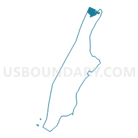
Voting District 7200066, New York County, New York
About
Outline

Summary
| Unique Area Identifier | 631585 |
| Name | Voting District 7200066 |
| County | New York County |
| State | New York |
| Area (square miles) | 0.70 |
| Land Area (square miles) | 0.41 |
| Water Area (square miles) | 0.29 |
| % of Land Area | 58.97 |
| % of Water Area | 41.03 |
| Latitude of the Internal Point | 40.87249740 |
| Longtitude of the Internal Point | -73.92861900 |
Maps

Graphs
Select a template below for downloading or customizing gragh for Voting District 7200066, New York County, New York


Neighbors
Neighoring Voting District (by Name) Neighboring Voting District on the Map
- Voting District 7100079, New York County, NY
- Voting District 7100081, New York County, NY
- Voting District 7100082, New York County, NY
- Voting District 7100083, New York County, NY
- Voting District 7100085, New York County, NY
- Voting District 7100086, New York County, NY
- Voting District 7200062, New York County, NY
- Voting District 7200063, New York County, NY
- Voting District 7200065, New York County, NY
- Voting District 7200067, New York County, NY
- Voting District 7200073, New York County, NY
- Voting District 8100080, Bronx County, NY
- Englewood Cliffs borough voting district 3, Bergen County, NJ
Top 10 Neighboring County Subdivision (by Population) Neighboring County Subdivision on the Map
- Manhattan borough, New York County, NY (1,585,873)
- Bronx borough, Bronx County, NY (1,385,108)
- Englewood Cliffs borough, Bergen County, NJ (5,281)
Top 10 Neighboring Place (by Population) Neighboring Place on the Map
Top 10 Neighboring Elementary School District (by Population) Neighboring Elementary School District on the Map
Top 10 Neighboring Unified School District (by Population) Neighboring Unified School District on the Map
Top 10 Neighboring State Legislative District Lower Chamber (by Population) Neighboring State Legislative District Lower Chamber on the Map
- General Assembly District 37, NJ (221,026)
- Assembly District 71, NY (122,886)
- Assembly District 81, NY (119,471)
- Assembly District 72, NY (117,394)
Top 10 Neighboring State Legislative District Upper Chamber (by Population) Neighboring State Legislative District Upper Chamber on the Map
Top 10 Neighboring 111th Congressional District (by Population) Neighboring 111th Congressional District on the Map
- Congressional District 17, NY (678,558)
- Congressional District 9, NJ (661,379)
- Congressional District 15, NY (639,873)
Top 10 Neighboring Census Tract (by Population) Neighboring Census Tract on the Map
- Census Tract 295, New York County, NY (6,941)
- Census Tract 160, Bergen County, NJ (5,281)
- Census Tract 293.02, Bronx County, NY (5,052)
- Census Tract 287, New York County, NY (4,035)
- Census Tract 299, New York County, NY (3,834)
- Census Tract 303, New York County, NY (3,753)
- Census Tract 307, New York County, NY (3,434)
- Census Tract 293.01, Bronx County, NY (1,875)
- Census Tract 297, New York County, NY (161)